


GPS Waypoint Finder

Description de GPS Waypoint Finder
Uses the GPS sensor, Magnetic Field Sensor and Accelerometer to determine the distance and direction to a GPS waypoint. Does not need to be held level. Free & No Ads.
Normally a compass needs to be level to get the correct reading, but this app uses the accelerometer reading to convert the magnetic field reading back to the horizontal plane.
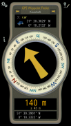
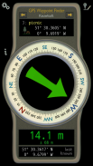
In addition to the direction and distance to the waypoint, a compass ring shows the current heading. North points to True North (i.e. The direction is corrected for the magnetic declination - the difference between magnetic north and true north).
The GPS reading and the time since that reading is shown at the bottom of the screen.
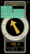
Use for geocaching, finding your car, hotel, or other locations.
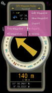
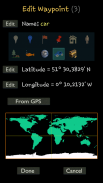
• Store up to 500 waypoints.
• Imperial or Metric units.
• Import and Export waypoints as GPX files.
Arrow colour changes to green at less than 30m and blue at less than 10m to make it easier for littler ones to identify that they've reached the waypoint.
Whilst walking, look where your going, not at the app or you might trip! The app tells you the direction of your destination, not how to get there.
Only as good as the sensors in your device. Use for Indication Only.
</div> <div jsname="WJz9Hc" style="display:none">Utilise le capteur GPS, capteur de champ magnétique et un accéléromètre pour déterminer la distance et la direction à un point de cheminement GPS. N'a pas besoin d'être tenue niveau. Annonces gratuites et Aucun.
Normalement, une boussole doit être de niveau pour obtenir la lecture correcte, mais cette application utilise la lecture de l'accéléromètre pour convertir le champ magnétique de lecture vers le plan horizontal.
En plus de la direction et la distance vers le waypoint, un anneau de compas indique le cap actuel. Points North à True North (c. La direction est corrigé pour la déclinaison magnétique - la différence entre le nord magnétique et le vrai nord).
La lecture de GPS et le temps écoulé depuis que la lecture est affiché en bas de l'écran.
Utilisez pour le géocaching, trouver votre voiture, hôtel, ou d'autres endroits.
• Stockez jusqu'à 500 waypoints.
• unités impériales ou métriques.
• waypoints importation et d'exportation des fichiers GPX.
Flèche changements de couleur au vert à moins de 30m et bleu à moins de 10m pour le rendre plus facile pour ceux Littler d'identifier qu'ils ont atteint le waypoint.
Tout en marchant, regardez où vous allez, pas à l'application ou vous pourriez trébucher! L'application vous indique la direction de votre destination, pas comment y arriver.
Seulement aussi bon que les capteurs dans votre appareil. Utilisez à titre indicatif.</div> <div class="show-more-end">
GPS Waypoint Finder - Version 1.00
(04-04-2016)
GPS Waypoint Finder - Information APK
Version APK: 1.00Package: com.keuwl.gpswaypointsAncienne Version de GPS Waypoint Finder


 3.64
3.64
Applications de même catégorie

Vous pourriez également aimer...


